The Grand Time
Tom's Journal
May 16 2007 - Day 1

After a 4:30 am wake-up in Granby, Gary and I headed for the Colorado River trailhead at Rocky Mountain National Park in the crisp, 29 degree air.
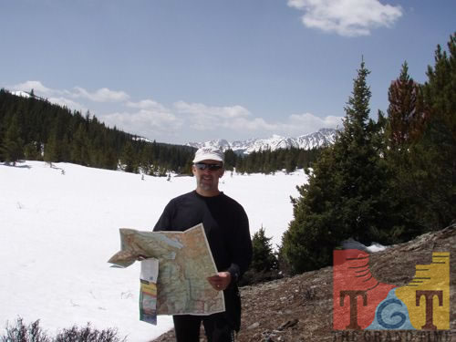
After packing snowshoes along with other essentials in our backpacks, we set out. We planned to go uphill toward the Continental Divide to the first point where we could step across the infant river which, fittingly, we expected to be at the site of an old mining town called Lulu City.
There were many areas of deep snow on the trail, but we made good time during the four-plus miles to Lulu City. There we found much more water than we anticipated, so we decided to try to make it three more miles to the top of the Continental Divide.
The route we chose-up Little Yellowstone trail to the La Poudre Pass over the Continental Divide-was difficult because of deep snow. It took us an hour longer than we expected, but we made it in fine spirits and, better yet, found a route back to Lulu City that was almost completely free of snow.
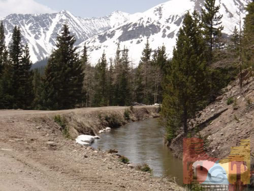
Part of the trail took us along the bank of a ditch that was built over a hundred years ago to divert water from the Colorado River watershed over the Continental Divide to cities and farms on the eastern plains. On this trip, what name would such a ditch have? The Grand Ditch.
At the divide, the “river” was only a vast snowfield two to five feet deep. Immediately to the west is Little Yellowstone, aptly named because it is a beautiful impassable gorge hundreds of feet deep. We could hear a series of waterfalls in it but getting close enough to look into it while standing on the deep snow would be too dangerous.
By the time we made it back down to Lulu City, it was early afternoon and, with the warm sunny weather, the snow was getting was much softer than it had been in the morning. So we strapped on the snowshoes and made our way back to the trailhead, where we arrived at just after 4 pm.
Due to a miscommunication our support team thought we had already begun kayaking and they had taken our support vehicle with our kayaks downstream to meet us. Fortunately, some very nice people from New Mexico, Judy and Wes Evans, drove me around the campgrounds of Rocky Mountain National Park until we found our crew.
After 5 pm we got in our kayaks and finally began the boat trip down the river, which was 36 degrees and so narrow (five to twelve feet wide) that many downed trees blocked it, forcing us to cross over or under them, or several times portaging around them.
We saw many Moose and Elk in the marshy open meadow through which the meandering but swift river flows, making only just over three miles before the sun went behind the Neversummer range to our north. The scenery throughout the day was absolutely stunning; the weather, perfect.
Today we dropped over 1,500 feet from the 10,000 foot-plus elevation at the top of the Divide; the fifteen-plus miles on foot along with the kayaking left few us with few muscles that aren’t sore.
After packing snowshoes along with other essentials in our backpacks, we set out. We planned to go uphill toward the Continental Divide to the first point where we could step across the infant river which, fittingly, we expected to be at the site of an old mining town called Lulu City.
There were many areas of deep snow on the trail, but we made good time during the four-plus miles to Lulu City. There we found much more water than we anticipated, so we decided to try to make it three more miles to the top of the Continental Divide.
The route we chose-up Little Yellowstone trail to the La Poudre Pass over the Continental Divide-was difficult because of deep snow. It took us an hour longer than we expected, but we made it in fine spirits and, better yet, found a route back to Lulu City that was almost completely free of snow.
Part of the trail took us along the bank of a ditch that was built over a hundred years ago to divert water from the Colorado River watershed over the Continental Divide to cities and farms on the eastern plains. On this trip, what name would such a ditch have? The Grand Ditch.
At the divide, the “river” was only a vast snowfield two to five feet deep. Immediately to the west is Little Yellowstone, aptly named because it is a beautiful impassable gorge hundreds of feet deep. We could hear a series of waterfalls in it but getting close enough to look into it while standing on the deep snow would be too dangerous.
By the time we made it back down to Lulu City, it was early afternoon and, with the warm sunny weather, the snow was getting was much softer than it had been in the morning. So we strapped on the snowshoes and made our way back to the trailhead, where we arrived at just after 4 pm.
Due to a miscommunication our support team thought we had already begun kayaking and they had taken our support vehicle with our kayaks downstream to meet us. Fortunately, some very nice people from New Mexico, Judy and Wes Evans, drove me around the campgrounds of Rocky Mountain National Park until we found our crew.
After 5 pm we got in our kayaks and finally began the boat trip down the river, which was 36 degrees and so narrow (five to twelve feet wide) that many downed trees blocked it, forcing us to cross over or under them, or several times portaging around them.
We saw many Moose and Elk in the marshy open meadow through which the meandering but swift river flows, making only just over three miles before the sun went behind the Neversummer range to our north. The scenery throughout the day was absolutely stunning; the weather, perfect.
Today we dropped over 1,500 feet from the 10,000 foot-plus elevation at the top of the Divide; the fifteen-plus miles on foot along with the kayaking left few us with few muscles that aren’t sore.
 Mile 1
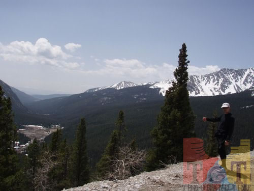 Mile 2
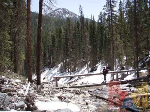 Mile 3
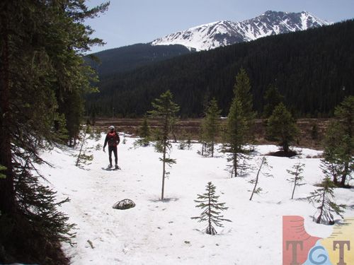 Mile 4
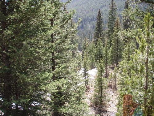 Mile 5
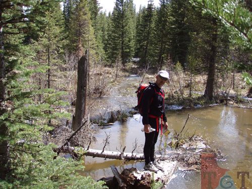 Mile 6
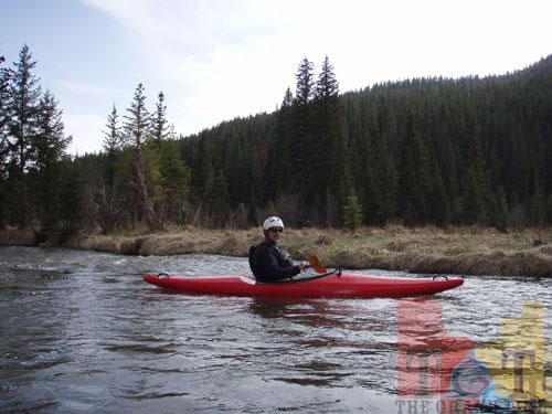 Mile 7
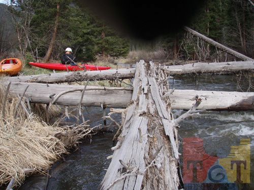 Mile 8
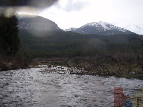 Mile 9
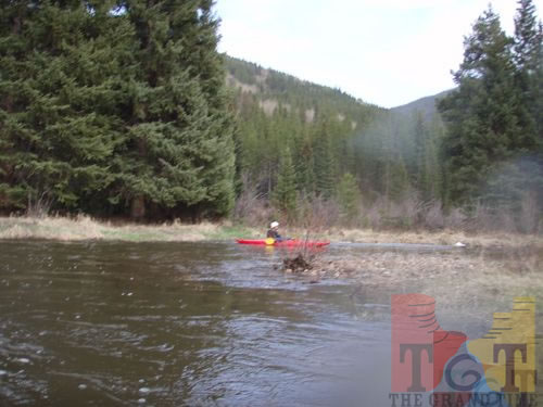 Mile 10